New Zealand Gold Prospecting & Metal Detecting Forums Archive


The forum has moved to community.paydirt.co.nz, see you there!

This forum is now an archive to preserve the knowledge and finds posted here.

Iggyrulz  
Posted : Wednesday, 5 February 2014 11:04:28 PM(UTC)
Iggyrulz

Rank: Gold Ingot

Medals: Donation: Made a donation helping cover the running costs of the site - thank you :)

Groups: Registered
Joined: 21/12/2013(UTC)
Posts: 438
New Zealand
Location: Dunedin

Thanks: 501 times
Was thanked: 327 time(s) in 196 post(s)
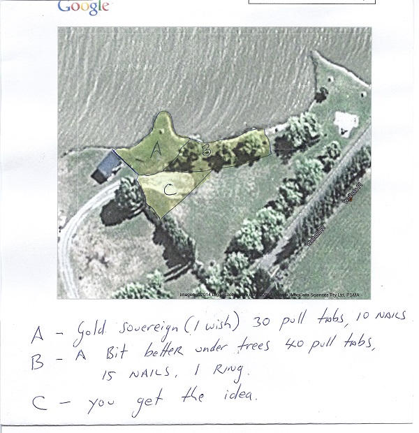
Lately I have started printing off a satellite map of the location I intend to hunt and revisit at a later stage. I try to break up the area into smaller pieces with obvious landmarks defining each search area. Once my pockets are full (usually with pull tabs). I mark on the map where I have hunted, then once home label the area with a reference number and then on the back record the finds relating to the reference number. Very easy to know exactly where you have been the next time you revisit the site, especially if it has been awhile. It is also interesting to know where you are finding
the best finds, i.e under the trees, by the tables, car park etc.
Over and out.
number8wire  
Posted : Thursday, 6 February 2014 9:27:29 AM(UTC)
number8wire

Rank: Gold Ingot

Groups: Registered
Joined: 10/06/2012(UTC)
Posts: 1,175
Man
New Zealand
Location: Christchurch

Thanks: 913 times
Was thanked: 880 time(s) in 425 post(s)
Hey mate, I really like the way you have thought this out. Particularly like the idea of recording the finds from the grid search on the back of that grid sheet.
Just thinking about it, you could go to the Dunedin library or national archives in Dunedin and see if you can find an old city map. If successful, you could overlay your Google grids with the old map to see what was built on that spot back in the day.......could be quite interesting, not to mention rewarding! Just a thought :)
TEKNETICS T2 SE plus X-POINTER
2016
Silver coins- 233
Other silver- 13
Gold- 1
Sovereigns-0
Spendies -$119.00
Iggyrulz  
Posted : Thursday, 6 February 2014 5:29:12 PM(UTC)
Iggyrulz

Rank: Gold Ingot

Medals: Donation: Made a donation helping cover the running costs of the site - thank you :)

Groups: Registered
Joined: 21/12/2013(UTC)
Posts: 438
New Zealand
Location: Dunedin

Thanks: 501 times
Was thanked: 327 time(s) in 196 post(s)
Sounds like a good idea #8 Thanks.
Iggyrulz  
Posted : Thursday, 6 February 2014 6:53:58 PM(UTC)
Iggyrulz

Rank: Gold Ingot

Medals: Donation: Made a donation helping cover the running costs of the site - thank you :)

Groups: Registered
Joined: 21/12/2013(UTC)
Posts: 438
New Zealand
Location: Dunedin

Thanks: 501 times
Was thanked: 327 time(s) in 196 post(s)
Just to clarify what I mean by using landmarks to grid the area, see pic.

Edited by user Sunday, 9 February 2014 12:04:54 AM(UTC)  | Reason: Not specified

Iggyrulz attached the following image(s):
google maps.jpg
kiwigoldhunter  
Posted : Thursday, 27 February 2014 4:00:58 PM(UTC)
kiwigoldhunter

Rank: Gold Dust

Groups: Registered
Joined: 10/08/2013(UTC)
Posts: 5
Man
New Zealand
Location: Auckland

Was thanked: 1 time(s) in 1 post(s)
thats a neat idea for sure
Mudwiggle  
Posted : Thursday, 27 February 2014 6:09:14 PM(UTC)
Mudwiggle

Rank: Gold Ingot

Groups: Registered, Moderators
Joined: 22/10/2013(UTC)
Posts: 742
New Zealand

Thanks: 182 times
Was thanked: 683 time(s) in 317 post(s)
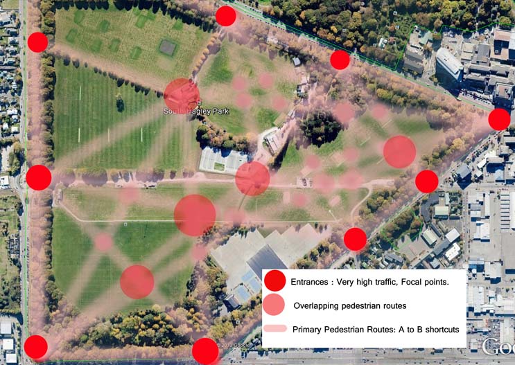
Here's one method I use.

Screenshot your park of choice from Google Earth, insert into Photoshop (Or just print it out and draw lines)
Identify access points, areas of interest (stadiums, water, shady trees) and focal points (eg. more shady trees, views, carparks, shortcuts etc)
Draw lines to connect everything to everything else (People will typically take shortest, easiest route, cut corners etc etc)
The higher the concentration of lines, the more people have probably passed that spot = more chance of goodies.
No intersections, low chances of bullion.

I have ignored the sidelines of playing fields etc, this would come down to local knowledge as to where people stand. For instance, one local 'paddock' gave me $12 on one sideline (nearest the clubhouse and carpark), nothing on the other (too far to walk).

As an example, here's a park at random ** Merely to demonstrate the theory, Looking at the grounds, I'd likely call most of this park off limits** I have assumed where entry points are, one or two may not exist, and there may be other. Local knowledge comes in here.

Anyway this should give you an idea of what I'm trying to say:

Mudwiggle attached the following image(s):
POA.jpg
Metal Kiwi  
Posted : Thursday, 27 February 2014 6:30:35 PM(UTC)
Metal Kiwi

Rank: Gold Ingot

Groups: Registered
Joined: 19/06/2011(UTC)
Posts: 1,210
Man
Location: Auckland

Thanks: 498 times
Was thanked: 484 time(s) in 322 post(s)
Another good low tech method is to follow your nose and trust your intuition.
I often start off gridding an area and then do the above for variety and fun. :-)


MK